…WINTER WEATHER ADVISORY BIRMINGHAM METRO TONIGHT AND TOMORROW MORNING…
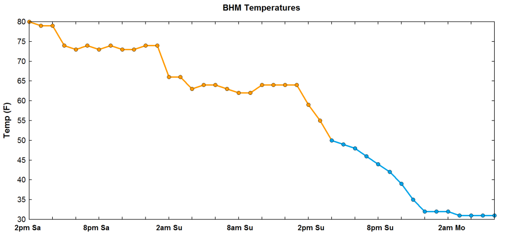
You have to love the Southern U.S., with our rapid weather changes. On one map covering mainly AL and parts of GA and MS, we have Winter Storm Warnings, Flood Warnings, and Tornado Warnings at the same time. Take a look at the chart below, showing observed and forecast temperatures by hour from 2 pm yesterday (80) to 6 am tomorrow morning (31).
The weather system that brought storms last night has moved through, but now an upper-level system to our west is associated with another, intensifying area of precipitation.
The cooler air has already moved in, with temperatures in Birmingham currently in the 50s. But if one goes up I-22 to Memphis, it drops quickly! 43 in Haleyville, 39 in Tupelo, 30 in Memphis. Several stations in west Tennessee have been reporting snow or freezing rain during the past hour.
3 pm temperatures
(pivotalweather.com)
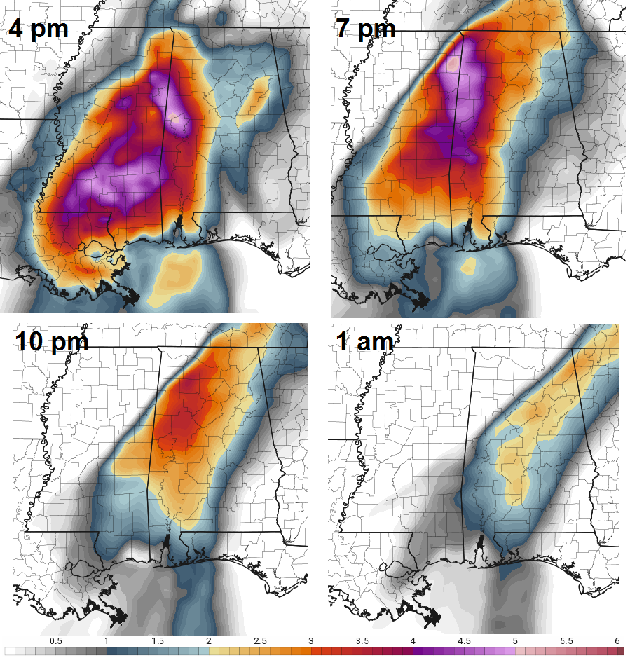
The above charts, both model predictions for 9 pm CST, show an intense upper-level wave approaching, and a surface low forming along the cold front in south Georgia. This is not the classic setup for a winter storm in Alabama, but with cold air moving in quickly and the forcing from the upper wave, expect precipitation, heavy at times, to spread across north and central Alabama between 4 and 7 pm. Surface temperatures will not drop below freezing until midnight, but lower atmospheric temperatures will be cold enough for snow in NW Alabama by 6 pm, and in BHM by 9 pm. The heaviest snow will likely fall in the Birmingham area between 10 pm and 2 am.
The ground is very warm. However, UAH research has shown that surface and road temperatures respond fairly quickly to falling temperatures, especially with wind. Most of the significant snow accumulation will be north of Cullman, and it will just be pretty to watch in Tuscaloosa, Birmingham and Anniston. But there will be scattered locations where heavier snow occurs, especially on mountains in central Alabama, where 1-2″ of snow may accumulate. I can’t remember a time when it snowed one day following 80 degree temperatures!
(pivotalweather.com, HRRR model snow accumulation overnight)
Temperatures will be freezing at the morning rush hour, so there may be ice on roads, especially bridges. I think all the kids are out of school tomorrow. If you have to go to work in the morning, please check the weather and road conditions, and go in late if you can. Temperatures will go above freezing by 11 am or so tomorrow in most areas.
It continues to feel like April in Alabama, with temperatures in the mid 70s. Dewpoints are now near 70, as Caribbean air is being pulled into Alabama! The fog this morning was incredible in some areas.
Trajectories showing where air that will be here tomorrow is coming from
La Nina continues to cause strange weather setups in North America. Check out these maps for 6 pm tomorrow. If one were to take the route that I and my business partner JP Dice took last Summer to see a decommissioned missile silo in Cooperstown, ND, temperatures would progress like this: 71 BHM, 37 St. Louis, 4 Des Moines, IA, -13 in ND. That is an 84 degree temperature difference! This is not normal, and when the temperature contrast gets this large, it is baroclinically unstable and any upper disturbance will intensify, form a surface low, and drop cold air south and take warm air north. Note the 160 mph jet stream! The cold air will move in on Sunday, with temperatures falling below freezing, and barely getting to 40 on Monday.
When it is this warm and humid at New Year’s Day, and a big dynamic system is headed our way, the threat for tornadoes and severe weather is a concern. A line of storms, some with damaging winds and the possibility of small tornadoes, will move through Alabama Saturday night. The question is whether or not any discrete supercells, like the one that caused a tornado at Lay Lake Wed night, will form out ahead of the line. Here is the deal…it is very warm and humid at the surface, but it is not that cold aloft, and many computer models suggest a layer of warm air near 4,000 feet (circled below) that would suppress most thunderstorm activity until the main line arrives late tomorrow night. However, if that warm layer does not materialize, with unstable air and high wind shear, we could see some tornadoes tomorrow afternoon and evening over northern and central Alabama. Doubtful, but we can’t rule it out right now.
NAM model prediction for BHM for 3 pm tomorrow
Tomorrow is a day to keep an eye on the weather. Either way, a line of storms with potentially damaging winds will move through around midnight tomorrow night. Make sure you have two sources of weather information, and go over your tornado safety plan if you didn’t the other night.
With the ominous satellite view at 1230 pm CDT today of an intensifying hurricane in the middle of the Gulf of Mexico…it has become the top news story of the weekend. I thought it would be good to write a blog on how a hurricane forms and how it works to produce such high wind, heavy rain, and storm surge.
1. Early development
Over warm ocean waters, where there is warm, humid air near the surface, thunderstorms sometimes form. In the case of tropical cyclone development, these thunderstorms are usually sparked by a tropical wave, or some kind of atmospheric wave moving through. Storms often tend to organize with each other a bit, as cool outflow boundaries create more storms. This forms a tropical disturbance. (The artwork is amateur…but makes the point. The colors represent radar colors of rain: green light, yellow moderate, red heavy).
An important characteristic of thunderstorms is that they release latent heat in the atmosphere. When water condenses from vapor to liquid, it releases heat, just like when you get out of the lake, pool, or shower and the water evaporates from liquid to vapor, it absorbs heat, making you feel cold even though it’s not cold. We show this type of process all the time in a skew-T, log-p diagram, or a graph of temperature and humidity with height in the atmosphere. Below is a typical one. Note the white dashed line, representing the air in a thunderstorm updraft, is 5-10 degrees C warmer than the undisturbed air around it. Since warm air at the same pressure is less dense than cool air, it accelerates upward through buoyancy. This is called instability. But, it shows that thunderstorms warm the upper atmosphere, and this is very important for hurricane formation.
If the storms are in a favorable environment (low shear, unstable air, plenty of humidity over the warm ocean water), they may intensify and organize, as shown below, into a tropical depression.
This is where the release of latent heat by thunderstorms converting water vapor to liquid water becomes very important. The pressure at the surface is caused by the weight of all the air above that point. If the air above a point gets warmed, it becomes less dense and lighter, so the pressure underneath it at the surface gets lower. Now we have a low pressure area. Air at low levels begins to flow from high pressure around the tropical depression toward low pressure in the tropical depression.
2. Development of a tropical cyclone
If the wind shear is low enough (we will get to that in a minute), and there is enough moisture and warm, unstable air above the warm water, this is where it starts becoming a true heat engine. The release of latent heat by storms lowers the pressure, causing convergence of air into the storm. The converging air can’t go into the ocean, it has to go up, creating more storms and releasing more latent heat. It is now a positive feedback loop, the pressure drops and pulls air in like a vacuum cleaner, air converges in, and a tropical storm forms.
The storms are still a bit disorganized in many tropical storms. But, the spin of the earth starts to take over here, too, keeping the converging air from filling the low pressure. The Coriolis force, caused by the spin of the earth, turns wind to the right in the Northern Hemisphere. Note the wind is blowing toward the low pressure in the center, but not directly towards it anymore. This is where the large counterclockwise circulation begins.
We mentioned wind shear earlier. Remember the main thing driving the low pressure in a tropical cyclone is latent heat released aloft by thunderstorms, causing the air to warm and get lighter, and lowering the pressure underneath. If there is little wind shear, the thunderstorms and latent heat can stay upright, keeping the lowest pressure near the center. If there is wind shear, the storms lean over, spreading out the effect of the latent heat and low pressure, not allowing pressures to drop as much near the surface.
Since the low pressure at the surface causes the high winds, and the convergence into the storm that forms more thunderstorms, wind shear tends to slow the positive feedback by keeping the low pressure area at the surface more spread out and less intense.
3. Hurricane
If the wind shear is low, and there is plenty of warm ocean water providing warm, humid air for storms, then the heat engine goes almost into automatic mode here, with the pressure continuing to drop near the center as big thunderstorms release huge amounts of latent heat. The pressure gradient becomes very large near the center of the storm, causing very strong winds, rotating counterclockwise because of the Coriolis force due to the spin of the earth. Yet, there is still just enough convergence, in addition to the unstable air, to keep storms going or intensifying even further.
To illustrate the warm air aloft in the hurricane as the main cause of the low pressure, take a look at the graphs below. The top-left one shows dropsonde data from a hurricane aircraft, and top-right shows a numerical simulation of a hurricane. In both cases, we can see air that is about 15 degrees C (24 degrees F) warmer than the surrounding environment. This warm air is much lighter than the air around it, causing the pressure at the surface to drop significantly, and become much lower than the air around it. This type of focused, upper air warmth gives the hurricane its low pressure and intense pressure gradient from high to low pressure, and the strong winds.
(Cross-sections through hurricanes, looking from the side)
(pivotalweather.com)
The chart above shows computer model expected temperatures around Hurricane Ida at 7 am Sunday, at 500 mb (about 18,000 ft). Note, in the center, temperatures are much warmer, 34 F near the eye. Temperatures drop off quickly to the mid to upper 20s 100 miles out from the center, and near 20 further out.
4. Hurricane Effects
The high winds are caused by the huge change in pressure over a short distance. The air tries to rush from high to low pressure, but the Coriolis (spin of the earth) turns it right until a rough equilibrium is reached where the wind is going fast enough that the Coriolis force and the pressure gradient force are in balance. Here is an example of surface pressure isobars (lines of equal pressure) and winds (colors) from Ida’s expected location Sunday afternoon. Note how, over areas with normal weather at that time, the pressure only changes about 2 mb (0.06″) over the distance from Birmingham to Meridian, MS, or about 100 miles. In the hurricane, the pressure changes from 980 mb near the center at Morgan City, LA to 1000 mb about 50 miles away. That is 20 mb per 50 miles, while over Alabama it is 1 mb per 50 miles. This causes very high winds. Note the wind flags are flowing counterclockwise but also have a convergent component.
The biggest danger in a hurricane is often storm surge. The strong wind pushing the surface of the water clearly makes huge waves. But, with a long-term push of the water in one direction, the entire surface of the water will no longer be flat, but get higher where the wind is pushing it, and lower where the wind is pulling it. The storm surge can cause water to be up to 15-20 feet above normal tide in some landfalling hurricanes. Depending on how flat the land is, this can push water a few 100 feet inland, or miles inland (as it did in Mississippi in Katrina). A smaller version of this happens on The Great Lakes, Lake Okeechobee, and even in the sloughs along a lake during a large thunderstorm (water rose 4″ in Bluff Creek during a 65 mph wind storm out in the river in May 2020).
(Orlando Sentinel)
Wind is strong and can destroy structures. But the destructive power of water can be much larger, because water weighs 1,000 times as much air. Wind of 115 mph has a force of 28 pounds per square foot, while water moving 11 mph has a force of 270 pounds per square foot. So, water surging in from a hurricane can do a lot of damage, and often does more damage than the wind even though few structures are fully submerged and get the full effect.
Tornadoes often form on the north and east side of a hurricane, too. As the hurricane moves inland, friction with the ground slows the wind greatly, and the Coriolis force drops quickly. So, air starts blowing in toward the center of the hurricane and starts to fill in the low pressure. But, this creates large wind shear between the ground and just a few 100 feet above the ground, where friction is not as much of a factor, and this wind shear, along with the unstable air around hurricanes, often produces favorable conditions for tornadoes.
Hurricane Danny in August 1985 came inland with 90 mph winds…not weak, but not a super strong hurricane. However, as it weakened and moved through the Southeast, it caused 34 tornadoes in Alabama alone, with 13 significant (F2+) tornadoes across the Southeast US. I recall JB Elliott, on NOAA Weather Radio that day, saying “if you see a threatening storm approaching, take shelter, because tornadoes are popping up sometimes faster than we can issue the warnings.” Some were killed.
Inland flooding is another big threat with a hurricane, especially if it moves slowly. Hurricane Harvey produced catastrophic flooding in Houston, TX in 2017, with some areas getting over 50″ of rainfall.
(Top: USA Today, Bottom: National Weather Service)
We will have a complete update on Hurricane Ida on this blog this evening, so stay tuned.
…Tropical Storm Ida has formed in the Carribbean as of 420 pm CDT…
The first significant Gulf of Mexico tropical cyclone of the year is forming in the Carribbean, SE of the Cayman Islands and south of Cuba. USAF hurricane hunters recently found higher winds on the eastern side of the system, and the official 5 pm EDT information from the NHC was updated at 520 pm EDT. Winds are currently 40 mph, and the storm is moving NW at 14 mph.
As shown in the above satellite image, the tropical storm is still not well-organized, with most of the thunderstorms (that release the latent heat that cause the pressure at the surface to drop…more in a blog later) NE of the center. However, with relatively light wind shear, the system should stay mainly vertical, and with warm water temperatures in the area near western Cuba, Ida will slowly intensify through tomorrow, when it is expected to be a strong tropical storm (winds 60-70 mph).
On a NW path, the storm will slowly intensify, with a brief lull over Cuba tomorrow, then it should become a hurricane over the Gulf of Mexico as it gets into the “Gulf Loop Current”, an area of extra water water in the central Gulf (water temps around 31 C, or 88 F). It looks like it will encounter weak wind shear across the Gulf, and get into the warmest water near the coast, so it has the potential to become a major hurricane, maybe Cat 2 with winds over 100 mph, by the time it makes landfall late on Sunday.
Hurricanes tend to follow the path of least resistance to go north. Looking at upper-level winds now, a strong ridge in the western Atlantic is keeping the storm moving NW, and that ridge will build into the Carolinas over the weekend, likely keeping the storm moving more toward TX/LA/MS, and less toward AL/Fl. However, a storm in the early stages still has extra uncertainty because getting an exact fix on the center is difficult.
(pivotalweather.com)
Note in the “spaghetti plot” of hurricane model tracks below, there is fairly good agreement in a landfall Tuesday evening south of New Orleans, then a move up through Mississippi on Monday. There could still be shifts in the track over the next couple of days.
Impacts for Alabama: It is too early to tell what kind of structure the storm will have. We should be on the east side of the track, so very moist air will be pushed into Alabama from the Gulf of Mexico Monday and Tuesday, with the possibility of thunderstorms producing more heavy rain (after one of the rainiest summers in a long time). As far as the Alabama Gulf Coast, unless there is a significant change in the position of the upper-level high pressure areas, the center of the hurricane should stay away. However, on the east side, there will still be winds 35 to 70 mph, along with heavy rain and maybe storm surge. It is too early to tell about that either…but main impacts should be Sunday and Monday at the Alabama coast.
We will post another update on Ida tomorrow afternoon, and over the weekend. UAH is sending two mobile instrumented vehicles, and several people, to Louisiana this weekend to get data in Ida. I will keep you posted on their activities, also.
The first tropical system to threaten the Gulf Coast this season is slowly developing in the Southwest Gulf today. Note that the storm is very asymmetrical…with most of the storms and clouds to the north and east of the center. With such disorganization, and an expected landfall within 48 hours somewhere between Houston and Biloxi (big range), the storm may not even become a named tropical storm, but if it does it would be Claudette. It will bring some winds, and a lot of rain, to the Gulf Coast, including the AL and NW FL beaches from Mobile to Panama City, but should not be a big wind or storm surge threat.
ECMWF model
We don’t have too much guidance from hurricane models because of the disorganization, but global models like the Euro (above), and the GFS take the storm up into Louisiana/Mississippi/north Alabama/north Georgia then into the Carolinas by Sunday evening. Note the trough of low pressure in the Mississippi River valley and Great Plains Sunday evening. That is a cool front moving in…and it will help keep the storm moving northeast and should prevent any major flooding over most of the Southeast. NCEP rainfall totals are maximized to the right of this general track (as they usually are). Some coastal areas may get rainfall totals over 7″, and rainfall of 3 to 5″ is expected across central and southern MS and AL, and parts of GA. So, some flash flooding is possible, and we have to consider the unpredictability of weak tropical systems.
NOAA total rainfall through Tuesday
If the center of the storm moves through MS and AL Saturday and Saturday night, there may be a threat for a few small tornadoes, mainly across northern Florida and the southern half of Alabama, due to wind shear east of the system. The energy-helicity index, a composite of shear and instability available for tornadoes, is expected to be sufficient for small tornadoes Saturday night and Sunday morning.
(pivotalweather.com)
For the Birmingham area, expect nice weather again tomorrow, but then increasing clouds and thunderstorms moving in on Saturday, continuing off and on Saturday night into Sunday. Some areas around here could get over 4″ of rain in locally heavy thunderstorms, but unless the track is drastically different than what we are seeing now, major river flooding should not be an issue. Just a stormy, breezy weekend. If you are headed to the beach, it will be a weekend of storms, wind, and rough seas, then probably improve starting Monday.
…PARTICULARLY DANGEROUS SITUATION TORNADO WATCH REMAINS IN EFFECT FOR MOST OF NORTH AND CENTRAL ALABAMA…
Current radar shows the intense supercell in Cherokee County, a tornado-warned storm approaching Florence/MSL, and a tornadic storm about to move into Sumter County. Plus, it shows a lot of non-severe rain and storms over northeast AL. This is keeping the warm, unstable air back in south and west Alabama.
An area of concern is developing in NW Alabama as temperatures are a bit warmer, the widespread rain is moving out, and the storms are starting to look more cellular. Satellite shows there may be a little sunshine in that area over the next 2 hours.
Because the surface low moved farther east than expected, and is currently in northeast Arkansas, the highest wind shear so far has remained to the east, over Alabama, while the most unstable air has been over Mississippi where it is warmer.
As the upper trough, surface low, and 850 mb jet continues to lift northward, wind shear may increase a bit in NW Alabama and some of the heavy rain may continue to thin out north of I-59 and west of I-65. If so, some of the storms in NE MS/NW AL could become tornadic like the one near MSL has.
Eventually, this evening, the storms will form into a line and move on through HSV and BHM around 10-11 pm. There have been numerous reports of damage and injuries with the long-track supercell that hasd moved from SW AL through BHM suburbs to Anniston area.
The loud storms that have been moving through the BHM area over the past 3 hours are elevated storms, with unstable air aloft but still cool, stable air at the surface. But the line of storms over west Alabama is in a confluence zone out ahead of the main low pressure area, that is ahead of schedule and according to my non-atristic analysis, is sitting in Southeast AR now. A couple of the storms are near the warm front (circled) and are starting to acquire rotation over TCL and Walker Counties…we will have to watch those. Note the wind blowing toward the orange confluence line I drew in on both sides. I expected this zone today, but not until afternoon. But it’s ahead of schedule too.
(pivotalweather.com)
With strong 850 mb winds (50-60 kt) blowing from the now very moist and unstable airmass over southern Mississippi, the warm front will continue to slowly move north as the surface low moves north along the Mississippi River. The storms north of the front help to slow it down due to the cooling effect of the rain (and it is a warm front after all)., but it will likely move on north slowly into the afternoon. The system moving a bit faster has helped us somewhat, and the longer we keep getting elevated storms north of the warm front, the more it will slow it down and give us less time to destabilize. But, it does look like the warm, unstable air will make its way into north and central AL just through advection by 1 or 2 pm.
You can see the shadows cast by the big storms in central Alabama on visible satellite…but there are breaks in the clouds over Mississippi, and temperatures are rising quickly over there. 70s as far north as Tupelo. Hard to say if we get sunshine here in Alabama today, but it is most likely in the high risk zone over northwest AL.
(SPC severe weather outlook and paragraph from it)
The SPC doesn’t often issue a HIGH risk at all. And they don’t often say things like they did in the above paragraph.
Despite the morning storms possibly delaying things and maybe even keeping a few areas a little less volatile, this is still a dangerous situation. The wind shear will still be very high (although not quite as high as we thought after the morning storms), but even 75% of the forecast numbers from last night still support tornadic supercells over western AL this afternoon…then a line of tornadic storms moving into central AL this evening. Don’t let your guard down…it still looks like a dangerous day. We will get a better handle on the effects of the earlier confluence zone and morning storms over the next 2 hours. That zone may stay in place from eastern MS into west AL through the afternoon…providing a focus for tornadic storms as the more unstable air moves in.
SPC is planning to issue Tornado Watches for much of AL and MS soon.
Current surface pressure (top) and 500 mb height (bottom)
It looks like the ingredients are coming together for a significant outbreak of severe weather, including a few long-track significant tornadoes, over the Southeast US over the next 24 hours. A sharp upper trough is already apparent over NM and AZ, and it will move eastward overnight and interact with a warm front currently stretching from Austin, TX to Montgomery, AL. The dewpoints along the Gulf Coast are not that impressive right now, relative to severe weather outbreaks, as shown in the current surface map (dewpoint in green). The dewpoints in the 70s are way out at the southernmost oil platforms.
However, the upper trough will cause rapid height falls along the warm front, and a low-level jet will form, that will transport warm, humid Gulf air all the way to Tennessee. Parcel trajectories indicate that the air currently over north AL is right now over west Cuba.
(NOAA/ARL)
The surface low will rapidly deepen, causing flow across the isobars at low levels because the atmosphere can not remain in balance. This will lead to very large wind shear and storm-relative helicity for tornadoes over the Southern U.S. tomorrow. Check out how quickly the European model deepens the surface low just between 1 pm and 7 pm tomorrow:
(WSI)
(pivotalweather.com)
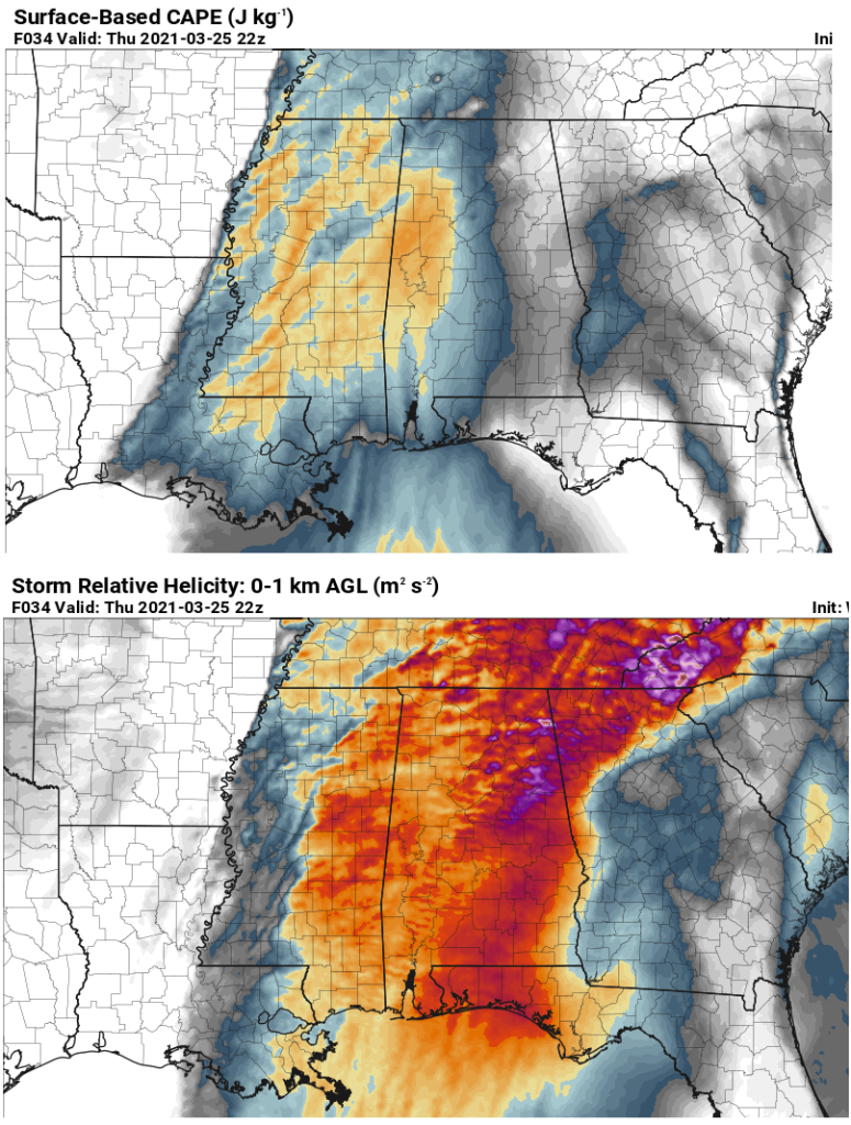
One complicating factor may be that showers and thunderstorms, likely not severe, will move northward through north and central AL and MS as the warm front lifts northward, much like the system last week. The European model at 1 pm (shown above) still indicates a good bit of rain north of a line from Jasper to Gadsden. How quickly this widespread rain moves out may determine how far north the warm, unstable air can go. But, there is no cold wedge holding it back this week like last week, so it will likely go farther north, at least to a line from Florence to Cullman to Anniston. Below is the expected CAPE (instability for thunderstorm growth) and storm-relative helicity (for storm rotation) expected at 22 GMT (5 pm).
(pivotalweather.com)
CAPE values increase from around 1,200 J/kg along I-65 to about 2,000 J/kg near the AL/MS border. SRH values are very high, between 300 and 400 m2/s2, from eastern MS into central AL. This combination creates a very high energy-helicity index (EHI), a good indicator of the likelihood of tornadoes, as shown below:
(pivotalweather.com)
At 22Z (5 pm), there is widespread EHI between 3 and 5, sufficient for intense tornadoes, centered near Columbus, MS, and including Tuscaloosa, Hamilton, and Demopolis. With upper-level diffluence and low-level convergence ahead of the dryline/surface trough, expect storms to form in those areas between noon and 3 pm, and some will quickly grow into supercells with large hail and tornadoes. That part of the state I just outlined, west of a line from Grove Hill to Jasper to Huntsville, has the greatest risk for tornadoes tomorrow afternoon. Storms will me moving quickly, from the SW (or about 230 degrees) at 55 mph, so that adds extra risk. By 04Z (11 pm), the EHI has a sharp edge at the back, and it appears that as the strongest wind shear pulls away after sunset, and surface temperatures cool a bit, lessening instability, the storms will form into a line and move through the rest of north and central AL during the evening. With EHI still 2-3, tornadoes will likely accompany some of these storms, along with straight line winds up to 70 mph. Below are computer model temperature profiles for Hackleburg, AL at 2 pm and 5 pm.
(pivotalweather.com)
Another complicating factor is a small but potentially very significant nose of warm air near 7,000 feet, mentioned in the previous blog, that could inhibit storms from forming in the afternoon. At Hackleburg, as the strongest forcing associated with the upper trough and dryline approaches, that warm cap of air erodes, so supercell development is likely in that part of the state. Below is a profile from Bluff Creek, AL, just west of BHM. Even at 6 pm, a but of warm cap is still present.
A good way to measure the effect of these “caps” is through convective inhibition (CIN), a number similar to CAPE but in reverse, meaning how much negative energy is there to hold back updrafts at low-levels. Below, at 5 pm, one can see an area of CIN from Jefferson County northeast into Blount, Shelby, St. Clair, and Etowah Counties. This may be a big key in preventing supercell storms a bit farther east. But it is a small warm nose and tough to forecast with the atmosphere changing so fast. It could be stronger and extend further north and west, preventing supercell storms in Huntsville, Jasper, and Tuscaloosa. Or it could be a little weaker, allowing supercell storms all over central AL. We will have to keep an eye on that.
(pivotalweather.com)
The expected EHI values of 3 to 5 are indicative of a significant severe weather event. There are still complicating factors that I mentioned that could weaken the system, including morning and early afternoon showers near the warm front, and the cap discussed immediately before this. However, we have to be ready for tornadoes and strong winds across all of north and central Alabama…because even if the supercells don’t affect you in the afternoon with potentially larger tornadoes, the squall line in the evening will still likely be intense and contain tornadoes.
Think about your usual safety plans for tomorrow afternoon and evening. Have multiple ways of getting severe weather warnings. I recommend NOAA Weather Radio and the phone app called “Tornado” that has a white icon with a picture of a red squiggly tornado with a plus at the bottom. You have to set it up for the places you want to be warned for. I will have another update tomorrow around or before lunchtime and go over more detailed safety rules, but you know what to do…lowest floor, away from windows and doors, away from outside walls, small room, get under something sturdy, helmets or pillows to protect your head, if you have cars in the basement, some recommend getting in them and getting down in the seats to protect yourself from falling debris.
UAH will be releasing weather balloons and have the mobile radars, wind profilers, lidars, and radiometers out across north Alabama, including Hackleburg, Courtland, and Huntsville, plus one weather logging vehicle driving around rogue to where we need data. To capture the warm frontal passage and destabilization from SW to NE, weather balloons and instruments will likely need to start taking data around 1700 GMT (noon) and continue until the main squall line passes Huntsville, around 10 pm. The main line will pass BHM around 11 pm. We hope to get a full picture of how the atmosphere changes going from the cool air north of the warm front to the warm, unstable air south of it, so operations may need to begin by 10 or 11 am at our SWIRLL facility at UAH.
This one has the potential to be bad, but things could still greatly slow it down, so no reason to panic. And, again, this is no April 27, 2011! EHI then was not 3 to 5, it was 8 to 11!
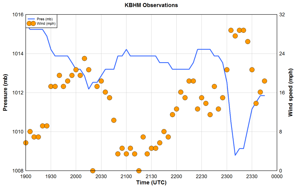
Time series of pressure (blue) and wind speed (orange dots)
Earlier this evening, it got quite windy outside, with wind gusts as high as 43 mph at the BHM Airport, and likely higher on ridgetops. These high winds were not caused by a thunderstorm downdraft, nor by more typical atmospheric pressure gradients. They were caused by a phenomenon known as a “wake low”. The pressure at BHM dropped 5 mb (about 0.15″) in only about 30 minutes, then rebounded fairly quickly. The peak winds occurred as the lowest pressure went by. These wake lows sometimes can produce winds over 70 mph, cause downed trees and power lines, and even cause injuries, as one did in Atlanta several years ago.
Sometimes, at the back edge of a convective rain event, something called a rear-inflow jet (RIJ) develops due to thermodynamic imbalances. Air rushes toward the front of the rain mass, in this case at speeds around 40 mph. These RIJ’s are sometimes forced downward, by evaporating rain above them, by being suddenly decelerated in the rain area itself, etc. This downward motion warms the air, and dries up raindrops, causing a sharp back edge to the precipitation, as shown in the radar image from the NWS Birmingham radar below at 2249 GMT (5:49 pm CDT).
This downward motion aloft also caused the air to get compressed, as if putting it into a tire, and warmed. Since warm air is less dense than cool air, low pressure is produced underneath the lighter air at the surface. This warming aloft is what caused the low pressure in the wake of the rain, known as a wake low. Below are cross-sections of reflectivity (rainfall) like you see above, and Doppler radial velocity (green is toward radar, or SE, red is away from radar, or NW). These cross-sections are along the white line in the above radar picture, at that time. You are looking at these images from the side, as if you are looking from the southwest and up to about 10,000 meters (30,000 feet).
Note the RIJ in the bottom panel as a jet of high inbound velocities (blue) descending from about 5000 meters to 3000 m between roughly northern Tuscaloosa County (left side of image) to Shelby County Airport (right side). Near the ground, air is rushing away from the radar (red) toward the low pressure created by the downward motion aloft. This is the wind from the SE that we felt this evening.
(SPC probability of severe weather within 25 miles of a point on Thursday)
…Another outbreak of severe weather, including tornadoes, possible on Thursday…
Here we go again. There is more uncertainty with this system than with the one last week, but it still looks threatening. First of all, for today (Tuesday), we have a system moving through with rain, and some thunderstorms. But, the best instability for any strong storms will be near the Gulf Coast, and no severe weather is expected north of a line from Monroeville to Opp to Enterprise.
Noon radarGOES full disk satellite image noon today
The above full-disk image from GOES is fascinating, in that it shows that daylight is fairly evenly distributed in the northern and southern hemispheres (we just passed the equinox), the sun just came up in Hawaii, and there is a second upper-level system (circled) in the southwest US, headed our way.
Upper-level winds now, 1 pm Thu (RAP/UCAR)
A significant upper trough is currently centered over southern California, and it will move out into the Southern Plains by Thursday morning. Here is where some of the uncertainty comes in…there has been some computer model disagreement on the strength of the upper system coming in. Compared to last week, this upper system does not look as intense over OK/AR/MO/KS on the American models. But, the European model has a stronger system. Even with the weaker upper system, there will not be a wedge of cool air coming in from the east this time to weaken most storms as they get north and east of Tuscaloosa, and the wind shear in this system will be high. The American GFS model this morning has come in with a classic severe weather setup, with a surface low in Tennessee by Thursday afternoon.
(pivotalweather.com)
The NAM, showing the weakest solution of the three major models, is still indicating a setup over north and central Alabama for tornadoes. As the upper system approaches, falling pressures will lead to a strong low-level jet stream, transporting warm, moist air from the Gulf into Alabama. This will produce unstable air over Alabama. With the surface low so close by and deepening as it moves across to our north, wind shear values will be very high.
(pivotalweather.com)
European model CAPE (top) and low-level wind shear (bottom)
Between 3 pm and 10 pm on Thursday afternoon, CAPE values will increase from west to east, to 1,000 to 2,000 J/kg. In addition, storm-relative helicity values, that indicate wind shear for storm rotation, will be quite high, between 300 and 500 m2/s2. These, in combination with high ground-level relative humidity, will produce a significant risk for tornadoes. This is measured by the Significant Tornado Parameter (STP), that used all three of these values. Below is a map of the STP for late Thu afternoon and Thu evening. Any value over 1 is sufficient for tornadoes, and we have some values up near 5 in some places/times.
(STP values, pivotalweather.com)
Note that the greatest threat for tornadoes will be over Mississippi and the northwest 1/2 of Alabama, mainly north and west of I-59, including Birmingham, Tuscaloosa, Huntsville, Florence, Jasper, Cullman, Hamilton, Fayette, and Demopolis. The greatest threat for supercell tornadoes will be in the late afternoon and early evening hours. By late evening, the storms will likely form into a line, but still have a risk of 70 mph winds and tornadoes as they move through. Expect the main line of storms in the BHM area between 11 pm and 3 am.
One other factor that could keep supercells from forming in the unstable air out ahead of the main line is a small cap of warm air aloft, as shown on the computer-model generated temperature profile below. The red line shows how temperature changes with height. The jump over to the right near 800 mb (about 7,000 feet) is a warm area. When thunderstorms build, they do so primarily due to buoyancy, or by the air in the storm updraft being warmer than the air around it. If the storms encounter warm environmental air, it could suppress them until the main line comes through during the late evening. However, if this warm cap does not appear, or the sun comes out and warms the surface temperature into the 70s so that the thunderstorm air just goes right through the cap, it won’t matter and we’ll have supercell storms with possibly large tornadoes like we did last Wednesday. Just another uncertainty right now.
This system will bring storms with heavy rain, strong winds, and possibly hail and tornadoes, Thursday night. It is possible that intense supercell storms will form earlier, between 2 pm and 7 pm, and produce large hail and significant tornadoes. It could get rough. We don’t know yet. The farther west you are, the larger the risk. We will know more as the system develops and gets closer, but every severe weather system is different. I will be watching this very closely. UAH plans to deploy groups to collect weather balloon and surface data, as well as Doppler wind lidar, wind profiler, and mobile Doppler radar data, across north Alabama. Another blog from me tomorrow evening.