

…OUTBREAK OF TORNADOES EXPECTED TOMORROW…

It looks like the ingredients are coming together for a significant outbreak of severe weather, including a few long-track significant tornadoes, over the Southeast US over the next 24 hours. A sharp upper trough is already apparent over NM and AZ, and it will move eastward overnight and interact with a warm front currently stretching from Austin, TX to Montgomery, AL. The dewpoints along the Gulf Coast are not that impressive right now, relative to severe weather outbreaks, as shown in the current surface map (dewpoint in green). The dewpoints in the 70s are way out at the southernmost oil platforms.

However, the upper trough will cause rapid height falls along the warm front, and a low-level jet will form, that will transport warm, humid Gulf air all the way to Tennessee. Parcel trajectories indicate that the air currently over north AL is right now over west Cuba.

The surface low will rapidly deepen, causing flow across the isobars at low levels because the atmosphere can not remain in balance. This will lead to very large wind shear and storm-relative helicity for tornadoes over the Southern U.S. tomorrow. Check out how quickly the European model deepens the surface low just between 1 pm and 7 pm tomorrow:


One complicating factor may be that showers and thunderstorms, likely not severe, will move northward through north and central AL and MS as the warm front lifts northward, much like the system last week. The European model at 1 pm (shown above) still indicates a good bit of rain north of a line from Jasper to Gadsden. How quickly this widespread rain moves out may determine how far north the warm, unstable air can go. But, there is no cold wedge holding it back this week like last week, so it will likely go farther north, at least to a line from Florence to Cullman to Anniston. Below is the expected CAPE (instability for thunderstorm growth) and storm-relative helicity (for storm rotation) expected at 22 GMT (5 pm).
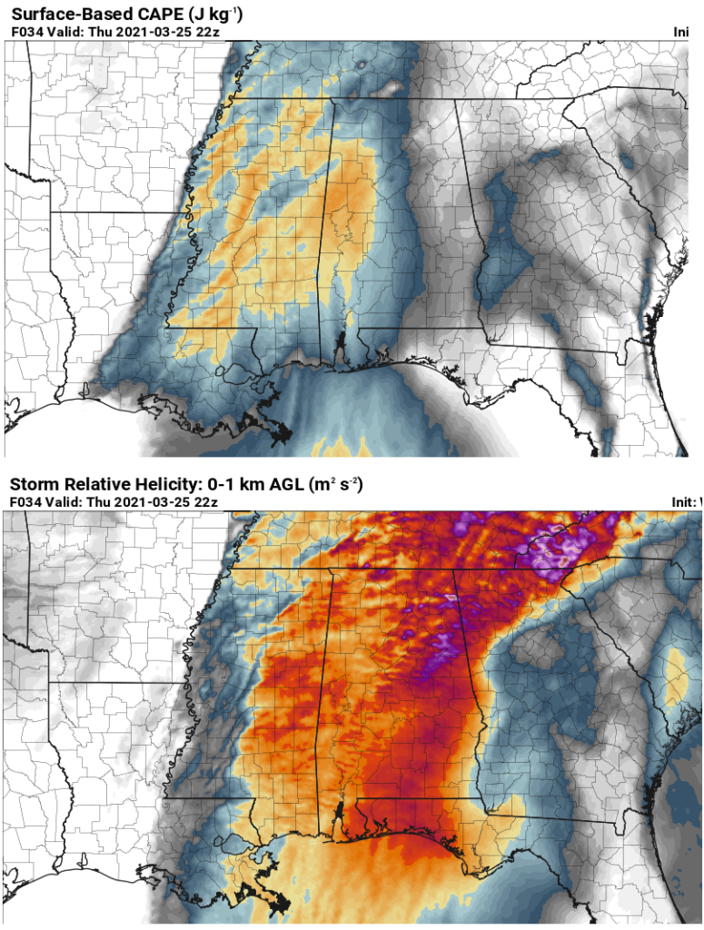
CAPE values increase from around 1,200 J/kg along I-65 to about 2,000 J/kg near the AL/MS border. SRH values are very high, between 300 and 400 m2/s2, from eastern MS into central AL. This combination creates a very high energy-helicity index (EHI), a good indicator of the likelihood of tornadoes, as shown below:

At 22Z (5 pm), there is widespread EHI between 3 and 5, sufficient for intense tornadoes, centered near Columbus, MS, and including Tuscaloosa, Hamilton, and Demopolis. With upper-level diffluence and low-level convergence ahead of the dryline/surface trough, expect storms to form in those areas between noon and 3 pm, and some will quickly grow into supercells with large hail and tornadoes. That part of the state I just outlined, west of a line from Grove Hill to Jasper to Huntsville, has the greatest risk for tornadoes tomorrow afternoon. Storms will me moving quickly, from the SW (or about 230 degrees) at 55 mph, so that adds extra risk. By 04Z (11 pm), the EHI has a sharp edge at the back, and it appears that as the strongest wind shear pulls away after sunset, and surface temperatures cool a bit, lessening instability, the storms will form into a line and move through the rest of north and central AL during the evening. With EHI still 2-3, tornadoes will likely accompany some of these storms, along with straight line winds up to 70 mph. Below are computer model temperature profiles for Hackleburg, AL at 2 pm and 5 pm.

Another complicating factor is a small but potentially very significant nose of warm air near 7,000 feet, mentioned in the previous blog, that could inhibit storms from forming in the afternoon. At Hackleburg, as the strongest forcing associated with the upper trough and dryline approaches, that warm cap of air erodes, so supercell development is likely in that part of the state. Below is a profile from Bluff Creek, AL, just west of BHM. Even at 6 pm, a but of warm cap is still present.

A good way to measure the effect of these “caps” is through convective inhibition (CIN), a number similar to CAPE but in reverse, meaning how much negative energy is there to hold back updrafts at low-levels. Below, at 5 pm, one can see an area of CIN from Jefferson County northeast into Blount, Shelby, St. Clair, and Etowah Counties. This may be a big key in preventing supercell storms a bit farther east. But it is a small warm nose and tough to forecast with the atmosphere changing so fast. It could be stronger and extend further north and west, preventing supercell storms in Huntsville, Jasper, and Tuscaloosa. Or it could be a little weaker, allowing supercell storms all over central AL. We will have to keep an eye on that.

The expected EHI values of 3 to 5 are indicative of a significant severe weather event. There are still complicating factors that I mentioned that could weaken the system, including morning and early afternoon showers near the warm front, and the cap discussed immediately before this. However, we have to be ready for tornadoes and strong winds across all of north and central Alabama…because even if the supercells don’t affect you in the afternoon with potentially larger tornadoes, the squall line in the evening will still likely be intense and contain tornadoes.
Think about your usual safety plans for tomorrow afternoon and evening. Have multiple ways of getting severe weather warnings. I recommend NOAA Weather Radio and the phone app called “Tornado” that has a white icon with a picture of a red squiggly tornado with a plus at the bottom. You have to set it up for the places you want to be warned for. I will have another update tomorrow around or before lunchtime and go over more detailed safety rules, but you know what to do…lowest floor, away from windows and doors, away from outside walls, small room, get under something sturdy, helmets or pillows to protect your head, if you have cars in the basement, some recommend getting in them and getting down in the seats to protect yourself from falling debris.
UAH will be releasing weather balloons and have the mobile radars, wind profilers, lidars, and radiometers out across north Alabama, including Hackleburg, Courtland, and Huntsville, plus one weather logging vehicle driving around rogue to where we need data. To capture the warm frontal passage and destabilization from SW to NE, weather balloons and instruments will likely need to start taking data around 1700 GMT (noon) and continue until the main squall line passes Huntsville, around 10 pm. The main line will pass BHM around 11 pm. We hope to get a full picture of how the atmosphere changes going from the cool air north of the warm front to the warm, unstable air south of it, so operations may need to begin by 10 or 11 am at our SWIRLL facility at UAH.
This one has the potential to be bad, but things could still greatly slow it down, so no reason to panic. And, again, this is no April 27, 2011! EHI then was not 3 to 5, it was 8 to 11!
Dr. Tim Coleman
